
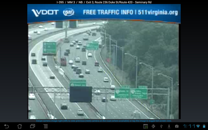


The Virginia 511 mobile application is the official source for traffic information from the Virginia Department of Transportation. A map based interface provides access to current and future road work, current incidents and traffic speeds, winter road conditions, scheduled bridge openings, and other events across the state. In addition, over 800 live video feeds are available to view in real-time from the state's roadside traffic cameras, with the ability to swipe to quickly move between cameras along a roadway.
The information, which is regularly and automatically updated from VDOT sources, is provided to the user both visually on the map, as well as through available voice alerts. The user can select basic mode, which limits visual feedback, and automatically provides voice alerts for upcoming events (in the next 5-15 miles) as the user travels down the road without interfacing with the device.
Current travel times are available for many pre-defined routes throughout the state, including all interstates and select primary routes. The user can select favorites from the list to view frequently traveled routes quickly and easily. A searchable list of road conditions is also available to view winter conditions, flooding impacts and other weather-related events for all interstate, primary and secondary routes maintained by VDOT throughout the state.
A “Reach The Beach” feature helps beach-goers by providing the latest travel times for multiple routes to and from Virginia Beach and the Outer Banks. As the user approaches a key decision point, the voice feature of the application will tell the user what the current travel times are from that point to the chosen destination via various options. When leaving the beach, the user can chose from one of four “Home “ destinations of Richmond, Fredericksburg, Skippers or Chesapeake.
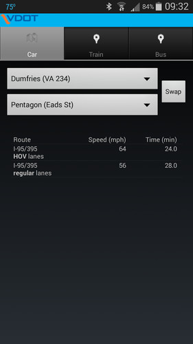
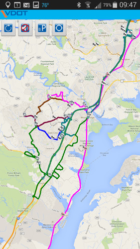
Real-time commuting information is available for commuters along the I-95/395 corridor in Northern Virginia through the application. This feature includes a map with real-time traffic speeds along the I-95/395 HOV lanes, as well as real-time status of VRE trains. Detailed information is also provided on the map for PRTC commuter bus routes and schedules as well as available park and ride lots along the corridor. A trip planner is provided for travel time and speed comparisons between the regular and HOV lanes for user-selected origins and destinations along the corridor. The trip planner also provides the real-time VRE schedules and the scheduled options along the PRTC bus routes.
Finally, access to VDOT's 511 Twitter feeds is also provided, with tweets on traffic incidents available statewide or for specific regions or corridors.
![The Clipse - Virginia Instrumental [Best Quality]](/img/play.jpg)